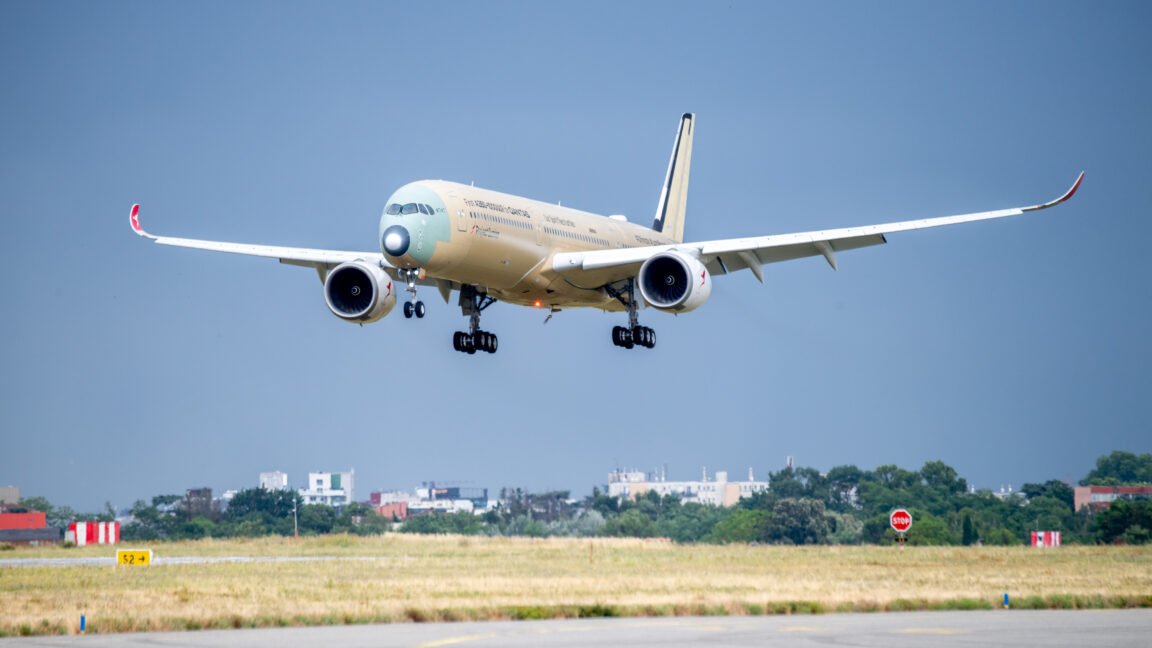
A new Airbus passenger jet completed an ultra-long test flight between Australia and France lasting more than 24 hours—paving the way for the world’s longest nonstop commercial flights starting up next year.
The Airbus A350-1000ULR was developed specifically for Qantas Airways’ planned nonstop flights between Sydney and either New York or London. The Australian airline has ordered a dozen of the new airliners for its Project Sunrise routes that aim to start offering tickets for sale in 2027.
The aircraft had been doing initial test flights near the Airbus facilities in Toulouse, France, with a small team of test pilots and test engineers before conducting its first ultra long-haul test flight last week. After taking off from Toulouse on July 23, it flew for 19 hours and 13 minutes before landing in Melbourne, Australia, on July 24.
That set the stage for the likely record-breaking return flight that lasted for 24 hours and 25 minutes between takeoff from Melbourne on July 27 and landing in Toulouse on July 28.
The flight from Melbourne back to Toulouse covered 12,460 nautical miles in total, according to Airbus. Flight-tracking service Flightradar24 shows the flight route stretched across both the Pacific and Atlantic Oceans along with North America.
To handle such ultra long-range flights, Airbus describes the aircraft as being equipped with an extra rear center fuel tank capable of carrying 20,900 liters (5,521 gallons). That extends the aircraft range by 1,000 nautical miles to ensure it can cover the nearly 10,000 nautical miles for the nonstop flights between Sydney and either London or New York.
Taking shifts for long flights
The aircraft also features a twin flight crew rest compartment designed to allow pilots to enter or exit rest areas without disturbing each other during commercial flight operations. Multiple pilots are required to take shifts during such long flights.
“To manage fatigue during the 20 to 23-hour flights we implemented four-hour shifts for each pilot, but we rotated the crew every two hours,” said Xavier Pepin, the Airbus test pilot who captained the return flight, in an Airbus post. “This staggered approach ensures that when a new pilot joins the cockpit, they overlap for two hours with the outgoing pilot.”
The first outbound flight to Melbourne included four Airbus pilots and five flight-test engineers who monitored aircraft systems in the cockpit or from work stations in the main cabin. But for the return flight to Toulouse, two Qantas pilots also joined the test flight crew that included three Airbus pilots and five flight test engineers.
“We have organized a schedule to allow a Qantas pilot to take the controls at specific times,” Pepin said. “These pilots are already qualified on the A350, and this mission provided them with their first experience with the -1000ULR variant.”
The aircraft drew considerable attention during its first ultra long-haul round trip. More than 3.6 million people tracked the aircraft during its return from Melbourne to Toulouse, according to Flightradar24. That made it the second-most-tracked flight ever on the flight tracking service, coming in only behind the Royal Air Force flight that carried Queen Elizabeth II’s coffin in 2022.
World record and higher fuel prices in sight
For now, Singapore Airlines currently offers the longest nonstop commercial flights that regularly connect New York City and Singapore and also holds the Guinness World Record for longest-duration nonstop scheduled flight. Such commercial flights typically take between 18 and 19 hours and currently use the Airbus 350-900ULR variant that can carry up to 161 passengers.
By comparison, Qantas Airways expects the maximum Project Sunrise flight time with the new Airbus A350-1000ULR to be 21 hours and 40 minutes during commercial flights between Sydney and New York or London—more than enough to set a new world record. The latest test flight certainly surpassed that benchmark.
Once outfitted for commercial service, each Qantas aircraft would carry up to 238 passengers. That represents the “lowest seat density of any A350-1000 in service in the world,” according to the Qantas Project Sunrise website. The Australian airline is making use of the extra space by including multiple self-serve stations with food and beverages and a “wellbeing zone” that includes room for passengers to stretch out.
Ticket prices have not yet been announced, but Qantas is allocating more than 40 percent of seats to passengers paying higher prices for First, Business, and Premium economy tickets. That could help the airline earn greater profits despite the lower number of overall passengers while pitching the nonstop routes as a unique premium service.
However, Qantas may also consider charging higher ticket prices if it’s still paying higher jet fuel costs in 2027 as a result of the US-Israeli war with Iran and ongoing disruptions to oil tanker traffic in the Strait of Hormuz. Airlines are already facing the prospect of paying an extra $100 billion on jet fuel in 2026 alone, with Singapore Airlines recently reporting its first quarterly net loss since the height of the pandemic in 2022, in part because of soaring jet fuel prices.


 Credit:
Chris Frawley / Amazon MGM Studios
Credit:
Chris Frawley / Amazon MGM Studios
 Credit:
AmazonMGMStudios
Credit:
AmazonMGMStudios
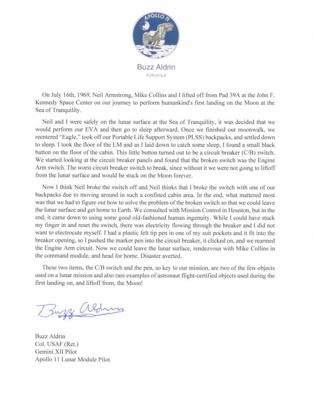 Apollo 11 astronaut Buzz Aldrin's letter describing the broken circuit breaker switch and felt-tip pin from his Moon mission.
Credit:
Sotheby's
Apollo 11 astronaut Buzz Aldrin's letter describing the broken circuit breaker switch and felt-tip pin from his Moon mission.
Credit:
Sotheby's
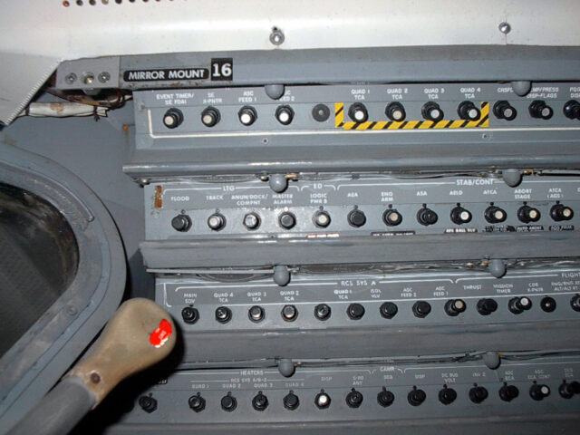 The location of the engine arm circuit breaker switch in the Apollo lunar module that was broken off on Apollo 11.
Credit:
NASA
The location of the engine arm circuit breaker switch in the Apollo lunar module that was broken off on Apollo 11.
Credit:
NASA
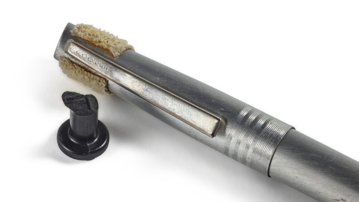
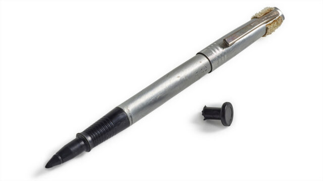 The broken circuit breaker switch that nearly ended Apollo 11, and the pen that Buzz Aldrin used to save himself and Neil Armstrong.
Credit:
Sotheby's
The broken circuit breaker switch that nearly ended Apollo 11, and the pen that Buzz Aldrin used to save himself and Neil Armstrong.
Credit:
Sotheby's
 Credit: